Where is Mount Nebo? How large is the Jordan River? How far is it from Dan to Beersheba? What size is the Sea of Galilee? Why is Palestine called “a land of milk and honey?” Can knowing about the terrain and location of cities within the Bible lands really help draw me closer to God? (Just a preview here: Yes! Yes, and more “yesses”!) If you love to share the word of God with others, these and many other related questions will be asked of you at some point during your tenure as a teacher. Perhaps you yourself have asked similar kinds of questions while digging into the text. Perhaps you have wondered why a certain battle took place in a particular area, and even more importantly, do questions like this matter? Is Bible geography critical to understanding the Bible? To this, I answer—with an absolute definitive—yes! Bible geography is important for a variety of reasons, and I encourage any student of the Bible who is serious about digging into the word and serious about coming to know and appreciate God even more to spend time learning about the regions and sites of the Bible lands. It might surprise you. Above all, it will allow you to see into the heart of God. Intrigued? I hope so because I am a big proponent of knowing more about the geography of the Bible lands.
To convince you, we must properly define our terms and realize that geography is much, much more than simply gazing at a map. Geography, in its most literal sense, is writing (graphe, meaning “a writing”) about the earth (geo, meaning “earth”). Thus, it most certainly involves the making of maps. Yet geography is so much more than determining distances, locating places, or the earth’s features. According to various geography textbooks and resources, it is a discipline and science that focuses on the differentiation of the earth’s surface as shown in the character, arrangement, and interrelations over the world of such elements as climate, elevation, population, land use, water, states, provinces, and political territories. It also incorporates into its analysis and explanations the disciplines of archaeology, hydrology, geology, climatology, sociology, and history. A study of Bible geography should likewise incorporate the various components of the discipline of geography.
The discipline of geography can be broken down into two main areas of focus (be patient…don’t stop reading yet): physical geography and human geography. The former is the spatial study of natural phenomena that make up the environment, such as rivers, mountains, landforms, weather, climate, soils, 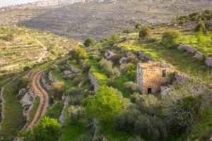 plants, and any other physical aspects of the earth’s surface. Human geography is the study of human activity and its relationship to the earth’s surface. Human geographers examine the spatial distribution of human populations, religions, languages, ethnicities, political systems, economics, urban dynamics, other components of human activity, and much, much more.
When we fail to understand the geography of the Bible, we will, in many ways, be unable to fully comprehend and appreciate the story of redemption. In the well-known and celebrated Westminster Bible Atlas, G. Ernest Wright says that “geography, history, and religion are so inextricably bound together in it [the Bible] that the religious message cannot be truly understood without attention to the setting and conditions of the revelation” (Westminster Bible Atlas, page 5). God’s message of salvation was revealed within a real geographical and historical setting, and so geography is important for the following reasons.
First, it reminds us that the Bible story was part of a real place and a part of actual human history. Unlike many religions of the world, the Bible story is not just a book of wisdom sayings and rules to live by. The commands and ethics of the Bible are unveiled within the context of real events and the lives of actual people. The late New Testament scholar and theologian C.H. Dodd said, “Some religions can be indifferent to historical fact and move entirely upon the plane of timeless truth. Christianity cannot” (History and the Gospel). These events and people of the Bible are a part of verifiable history. The Bible story isn’t founded on myth or cunningly devised fables. When the Bible speaks of Abraham leaving among the Chaldeans (Genesis 11) and becoming a sojourner in and around places like Gerar and Egypt, one can easily identify those ancient cities and regions today. Important cities and places like Jerusalem, Hazor, Bethlehem, Caesarea, Ashdod, and the Jordan River were—and are—real places. Those same real places and the same real settings, when examined in our modern era, can help us in developing greater faith and devotion to God. Knowing these facts helps us to see that the commands of God are both rational and possible for us today. Real people living in real places, enduring real challenges and hardships of life, trusted in God and obeyed His commands. This means we can trust and obey Him, too.
Bible geography provides a window into the ancient past. By sifting through the archaeological data, by traveling down the pathways of the Bible lands, and by traversing through the passages of its ancient cities, trade routes, and caves, we come to not only better understand and appreciate the challenges of life faced by our religious forbearers, but we also come to see how God used the historical and geographical setting 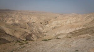 of the Bible lands to refine and develop their faith. Those same real places and settings, when examined in our modern era, can likewise become a passage for us in developing greater faith and devotion to God.
Second, Bible geography helps us to visualize the events and places of the Bible story. If, for example, we understand that the environment between Jerusalem and Jericho is rugged and harsh, then we can more fully appreciate the sacrifice and challenges faced by the hero in the parable of the good Samaritan (Luke 10). Known today as the Judean Desert, this area is riddled with numerous caves and crevices which make it ideal for hiding in secrecy. Thieves and fugitives could find refuge in this deserted place and lie in wait for unsuspecting travelers. In stopping to minister to the victimized man of the Judean desert, the Samaritan was not only putting himself at risk but was also taking on a tremendous burden to aid and transport a helpless man down a largely inhospitable and uninhabited road. Understanding the geographical setting makes what the Samaritan did to render aid all the more remarkable.
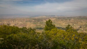 Likewise, by carefully considering and examining the geographical elements of the Bible, either in person or through photographs, books, and maps, the stories of the Bible not only become real to us but also become more vivid and accurate. Consider, for example, the notion that the Bible lands are always hot, barren, sandy, flat, and largely uninhabited. The land in several places is indeed hot and inhospitable, but the heartland of Israel was truly “a land flowing with milk and honey” (Exodus 3:17), a phrase referring to the opportunity for agricultural abundance. It is also very diverse in its terrain, elevation, soil, and climate. It is rugged in some places and yet tremendously fertile in others. Comprehending the terrain and climate, along with having an understanding of its geopolitical position as a “land between” hostile nations to the north and south, will help us to better appreciate the challenges and rewards experienced by the people of God.
The land promised to Israel lay within a small part of the agriculturally rich portion of the fertile crescent. To the north, the Golan/Bashan region is lush with vegetation. The climate is cool, and the abundance of rain and snowmelt from Mount Hermon produces a series of gushing springs that form the headwaters of the Jordan River. To the extreme south and east of Jerusalem lies the desert. In the nearby Negev Basin,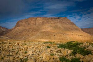 where only 12 inches of rain per year may fall, the land is still capable of growing wheat and pasturing flocks. As one moves to the center, evidence of the land’s production can still be seen today in the many fruits and vegetables still being harvested, just as they were in Bible times. Olive trees, grape vineyards, pomegranates, wheat, and numerous herbs and spices are all still being grown in abundance. Knowledge of these facts and the agricultural practices associated with them is essential to understanding the imagery employed within scripture. The prophet Isaiah’s references to building walls, watchtowers, and winepresses (Isaiah 5; cf. Matthew 21:33) were used as important metaphors for describing the work of God within the life of Israel and the fruit of righteousness He expected to see in return.
Similar to the frustration and sadness a landowner might experience when cultivated plants did not produce, so God expressed His sadness and anger through agricultural metaphors when describing the lack of faith and obedience of His people (see also Jeremiah 2:13-14). The decomposition of weathered limestone and basalt produced rich minerals within the soil for growing healthy plants, but the rocky and hilly terrain also meant that hard work was required in preparing a terraced field, digging a winepress, and cultivating crops. Farming in the rocky soil of the Bible lands took a lot of effort and care, just as God had taken great care to cultivate His people with the expectation that they would produce fruits of righteousness. Imagine His disappointment when they produced only wild and inedible grapes. Knowing the geography of the land can give us a clearer window into the heart of God.
Third, it heightens the emotional and sensory impact of the Bible stories and lessons. After taking refuge in the cave of Adullam, David soon found himself retreating to a refuge in the strongholds and hiding places of the Judean Wilderness. King Saul’s murderous jealousy drove David further and further away from the people he loved and sought to help (1 Samuel 22-24). Largely uninhabited, this barren territory is wedged between the Hill Country of Judah and the lifeless waters of the Dead Sea. While little vegetation and water exist, the wilderness still has a redeeming value. Its deep ravines, major  uplifts, and numerous caves provide many places known as strongholds.
The Hebrew word for “stronghold” is mesudah, and it is often associated with a high mountaintop, fortress, hiding place, or castle. It was to places like this where David would have come for security, peace, and protection (1 Samuel 24:22). One of David’s strongholds was most likely the enormous escarpment known today as Masada. The impressive natural land feature would have been an ideal hiding place for a small band of men and a strategic place for defense.
It was on a rugged, isolated mountaintop and in the darkness of the caves and hiding places of the Bible lands where David grew in his faith and love for God. Because of his wilderness experience, he gained perspective on what was truly most important. Because of his hardship, he also introduced the world to the greatest poetry ever composed. His time of pain and retreat brought the world the powerful and vivid imagery used throughout many of the biblical psalms. Those prayers and the symbolism they contain have helped many of us in our own times of wandering through a wilderness of despair. The imagery of a dark valley (Psalm 23), a rock badger (Psalm 104), a rocky crag (Psalm 18), and a dark cave (Psalm 57) were  tools used in explaining more about the security and goodness of God. The message of those psalms, especially when considering their geographical context, offers hope reassurance, and a better understanding of the nature of God.
To be continued…

